Original article
"Red Trail" was in use from 1913 until the state converted road designations from colors to numbers in 1917; although color designations were also used on maps until sometime after 1921. Trail names resurfaced recently to leverage their historical significance and invoke nostalgia for purposes other than historical accuracy. The "Red Trail" name is currently assigned to a Mandan District elementary school, an ethanol production facility in Stark County, as a street name in northeast Mandan and used for commercial promotion of a scenic highway.
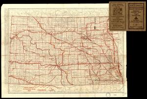
<Click to Enlarge> When colors were used to designate highway routes, Red Trail began at Pembina and ran down the Red River Valley past Fargo to Fairmont before turning west to Oakes. Early maps sometimes denoted the road along North Dakota's eastern border as "Meridian Highway" due to its proximity to the 6th Principal Meridian (the designator used an effort by Texas businesses to promote a north to south "Pan-American Highway.") Red Trail is also used to identify the east-west road in the south half of North Dakota, from Fargo to Jamestown to Mandan-Bismarck and on through Dickinson to the state's western edge near Beach.
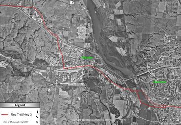
The actual Red Trail passed through Mandan from the Missouri River bank either from its original landing south of the car bridge approach or the later river access within today's Captain's Landing Township. After meandering west and north across the open field to the south side of the railroad tracks, it followed the tracks until crossing north across the tracks near the at-grade surface near today's BisMan Avenue (i.e., east of North Star Steel on "The Strip.") The trail continued west until it joined the east end of Main Street. <Click to Enlarge>
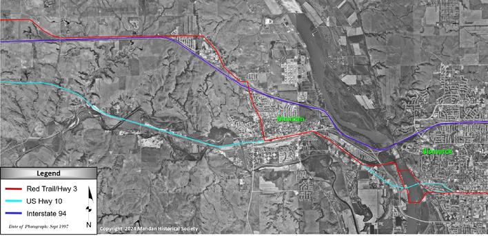
As it continued west on Main Street, the trail turned north at Sixth Avenue NW (originally designated as McCullough Avenue) to take advantage of higher ground and easy terrain to avoid frequent wet and muddy roads along the Heart River west of town. Once reaching the top of the northside river bluffs near today's intersection at Sunset Drive and "Old Red Trail" to pivot northwestly for some distance until turning one final time to exit the city limits directly west. Eventually trails were replaced with improved "roads." Earliest roads typically followed established trail routes with their shallow elevation changes and easy stream or river crossing locations. These roads would eventually be abandoned for better, more efficient routes which benefited from heavier construction equipment and better materials. Even today, original wheel ruts remain visible on some historic trails including the Bismarck to Deadwood stagecoach route. The map presented below (which can be enlarged by clicking on it) compares three of the most traveled east-to-west overland routes in the Mandan-Bismarck area.
<Click to Enlarge>
Background - Early Recorded Routes
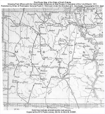
Travel by water was eventually supplemented by overland roads as frontier settlers ventured beyond rivers, streams and railroad stations. Expedition routes undertaken by military troops were recorded and formally documented as maps. Trails were often referred to as the person or agency that blazed the route or the event that established it. Many US Army-prepared maps were adapted for use by the US Post Office as the earliest Postal Routes. Earliest overland routes were referred to as "trails" and barely adequate for horses, stagecoaches and animal-drawn wagons. They typically were a simple worn grass path. <Click to Enlarge>
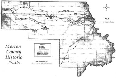
<Click to Enlarge> Fort McKeen / Fort Abraham Lincoln was established to facilitate the westward expansion of the railroad. But the nation's economic collapse in 1873 was the immediate cause which forced the railroad to pause construction east of the river at Bismarck. The mission at Ft. Abraham Lincoln pivoted to scouting a location for a new fort in the Black Hills to support operations in the ongoing "Indian War" and identified a location for the future Fort Meade. Their missions again involved navigating overland in previously unmapped territory.
Roads Denoted by Colors
Prior to 1913, roads were maintained by city and county road supervisors. When the ND State Highway Commission and associated State Highway Department was created, colors were used as the first highway designators to identify roads, most hardly more than a two-track trails at the time. And sometimes not even that well established. Planning on a state-wide and eventually national basis began. The first state highway map preparaton was also authorized.
Roads Denoted by Numbers
By 1917, the Highway Department began using numbers rather than colors. Now the east-west route from Fargo to Mandan and west to Dickinson, Medora and Beach being designated State Route 3. In 1921, the State Highway Department introduced embedded meaning to its highway designations, with even numbers for east - west routes and odd numbers for north - south routes. State Route 3 became ND Highway 6.
Mid-Winter Ice Crossings, Boats & Ferries
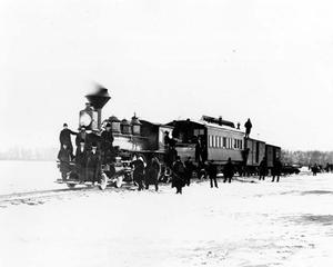
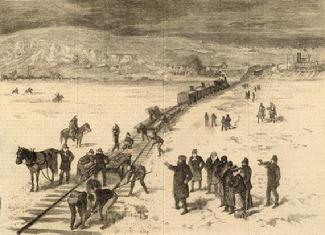
Crossing the Missouri River posed the greatest challenge. To facilitate the construction of the rail line west of the river and the rail bridge itself, chief bridge engineer Thomas Rosser took the bold move to construct a rail crossing across the frozen river. Not only were materials moved, but locomotives and rolling stock railcars were also moved. These operations occurred twice during the winters of 1878-79 and 1879-80, corresponding to the railroad's effort to supply the buildout of the railroad line west of the river while the railroad bridge was under active construction.
<Click to Enlarge> <Click to Enlarge>
In warmer months, boats were used to shuttle passengers and items across while awaiting the first bridges to be installed. Missouri River crossings remained largely dependent on river ferries to transport items and passengers from one side to the other until an automobile bridge was installed in 1922. Ferry landing locations evolved as needs and equipment changed. John McGinley from Mandan was among the earliest operators to provide ferry services. He would row his customers and their belongings across the river in a small skiff in the 1870s and early 1880s. The earliest operations were conducted on the eastside for Bismarck was along a bank straight west of Front Avenue (FYI until March 1927 was known as Front Street). This river crossing was incorporated into the route between the Capitol to Fort Abraham-Lincoln Road funded by the ND legislature in 1909 and built by inmate labor from the state penitentiary. The Front Avenue landing was replaced by the landing on the north edge of the riverside warehouse district above the steamboat dry dock. This location benefited from rail access and a better road. The west side also had multiple landings. The Heart River water access was key to the success of the operation at Motsiff south of Mandan (near today's Sitting Bull Bridge / Dogtown / Stage Stop Bar & Grill) and served both Mandan to the north and Fort Lincoln to the south. A bridge across the river improved access. But in 1878 as efforts to begin construction of the rail line west of the river in anticipation of the river bridge, a rail spur was installed to the west bank across from Bismarck's steamboat landing to take advantage of the rail sidings on both sides. Once the rail bridge was completed in 1882, most commercial goods as well as some passengers were transported via train. But many local people risked a walk across the bridge between trains rather than using the local boat ferry.
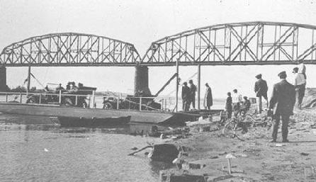
In 1916, the Mandan Automobile Club and the Bismarck Commercial Club purchased the river ferry operated by Walter Gossard. The city boosters paid Gossard $2000 as a down payment on the gasoline ferry and began a campaign for the $1300 balance. The Bismarck and Mandan clubs formed a stock corporation capitalized at $2000. Daily income was in excess of $25 per day, with the expectation to repay the stock subscriptions by summers end. 1909 Mandan to Bismarck Car Ferry
In 1916, 12 trains operated in each direction daily. Additional "special" trains were operated between Mandan and Bismarck for specific events such as opera performances and the State Fair in Mandan. The demand for wagon and/or car movement by ferry dropped to a point where the revenue collected was not sufficient. The City of Mandan deemed it an "essential service" and began to subsidize its operation. The "Marion" ferry was the last; and discontinued operation in 1922.
Auto Trails to Highways - The Good Roads Movement
Through the 1920s, nationwide local commercial booster groups banded together to persuade government officials to spend money to improve roads which were frequently scraped ground. These "auto trails" frequently followed established historic trails which had been originally established due to their ease of use (level topography, shallow stream and river crossings, etc.) Examples in North Dakota were Custer's Trail, Old Trails Highway (a designation duplicated by other groups) or the Bismarck to Deadwood Stagecoach Trail. This patchwork of roads promoted by hundreds of trail associations resulted in overlapping trails and/or sometimes lacking connections to the adjacent roads. But worse, sometimes mapped through towns that paid dues rather than efficiency per a history prepared by the Federal Highway Administration history. Destination signs and road designations were not standardized. Road maps were not widely available.
In 1902, nine clubs met in Chicago IL banded together to coordinate efforts for better roads. The American Automobile Association (AAA) was instrumental in gathering and sharing road data. The AAA formally incorporated as a separate umbrella organization in 1910. The focus shifted to advocate for a nationwide network of improved roads and to assure roadside services were available in increments no farther apart than every 120 miles. Preparation of road maps for the motoring public was also key.
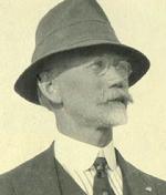
Anton L. Westgard Anton L. Westgard, "The Great Pathfinder," was a Norwegian immigrant with a thirst for adventure. Previous to 1913, Westgard crossed the continent three times in 147 days in a stock automobile while collecting data for a series of maps published by the AAA. His 1911 cross-country field survey via automobile led to the first transcontinental route from New York City to California along the Hudson River and the shores of the Great Lakes; then onto Omaha, Denver, Salt Lake City and Sacramento. This coast-to-coast route would come to be known as the "Lincoln Highway."
In 1913, Westgard took a position with the National Highways Association. As vice-president of the NHA, he left New York City on a 17,000-mile trip to compile first-hand data by which the association hoped to use the data to convince the federal government to build roads. This trip included scoping out the best route for what would later become the National Parks Highway. Early proposals selected the northern route from Grand Forks to Minot to Williston to avoid building a car bridge across the Missouri River. It was also a more direct route to northern Montana's Glacier National Park. But the southern route across the state won out as inclusion of the state's largest city, the state's capital city and access to the state's National (Memorial) Park near Medora was deemed more beneficial to the state.
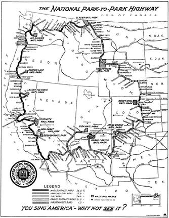
<Click to Enlarge> The National Park Highway Association, was formed in 1913 worked to construct a improved road across the northern US to connect to Yellowstone National Park. Like most of the trail associations, a chapter was formed in each state to spearhead efforts in their area of influence. (Its North Dakota office was located on Main Street in Bismarck in the 1920s.) Stephen Mather, the first director of the National Park Service, had a vision for a circular series of roads between 13 National Parks in the western United States to meet the growing demand for access by the public. The National Park-to-Park Highway Association was formed in 1915 to coordinate efforts to create National Park Circuit Highway, added in part for Anton Westgard. As denoted on the adjacent map prepared in 1922, Red Trail (then referred to in ND documents as State Highway 6) across North Dakota was labeled as the National Parks Highway.
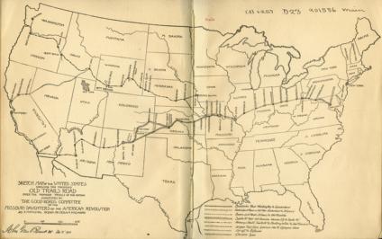
While the AAA did identify multiple cross-county auto-trails, the early nation-wide efforts to construct improved roads focused on providing a transcontinental overland route to California destinations to support the Panama-American Exposition in San Francisco in 1915 and the Panama-California Exposition in San Diego through 1917. To this point, left large portions of rural sections of the country were under served. <Click to Enlarge>
Automobile Bridge Completed
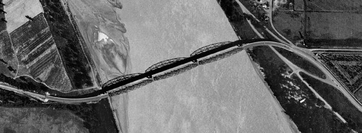
1938 17Aug Aerial Photograph showing gravel roads on each side of paved bridge approaches
In 1922, the North Dakota Memorial Bridge (later renamed the ND Liberty Memorial Bridge) was the first automotive bridge to span the Missouri River in the upper Midwest.
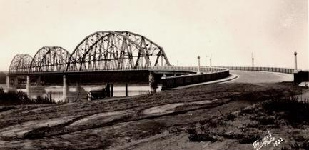
Located on a ND State Route 3, it was dedicated to the young men and women who served and died in World War I. The route was redesignated as part of US Highway 10 in 1926 when the Federal Highway System numbering was adopted by the ND Highway Department.
The main traffic volume on the eastside originally traveled across a swept eastside brick bridge approach via Front Avenue. The 4-mile distance between west Bismarck and east Mandan was largely rural at this time. Two years after the bridge's opening, the road between Bismarck and Mandan was resurfaced as a 2-lane concrete highway in 1924.
Memorial Highway
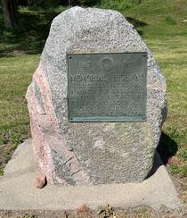
On Memorial Day May 30, 1925 the 4-mile road and river bridge between Bismarck's west Front Avenue at Hannifin Street and Mandan's Main Street was renamed "Memorial Highway" to honor all our service men and women who died in World War I. A copper plaque mounted on a granite fields tone plinth, donated by the Women's Auxillary of Bismarck's American Legion Post, was installed at its east end at the intersection of west Front Avenue and Hannifin Street, where it remains today. <Click to Enlarge>
Bismarck's west end of Main Avenue on the north side of the railroad tracks was connected to Front Avenue on the south side of the tracks via a three-block long dogleg street beneath the railroad viaduct ending at the Front Avenue-Hannifin Street intersection. Note: The railroad viaduct was eliminated in 1994 during the Washington St-Main Ave intersection reconstruction project. A railroad viaduct over West Main Avenue in Bismarck was installed in 1959, and the street paved to the eastside approach. West Main Avenue had only been connected by a narrow two-track and eventually gravel road that passed over the railroad tracks at grade approximately 200 feet northwest of the current above-grade viaduct. In the 1960's, businesses on the west side of the river began commercial promotions including "Zip to the Strip" and "On the Strip" tag lines to leverage the improved access especially from Bismarck's west side. This area quickly gained the nickname of "The Strip" and distinquished itself to the commercial developments underway adjacent to the new connection to Bismarck's west Main Avenue. Recall that this portion of rural Morton County would not be annexed by the City of Mandan until 1974.
ND Highway 6 Redesignated as US Hwy 10
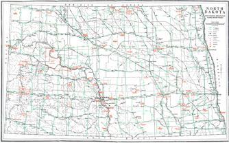
<Click to Enlarge> At the recommendation of the American Association of State Highway and Transportation Officials (AASHTO), the US Department of Transportation adopted a identified nationwide a system of federal highways and used standardized designations based on numbers. In 1926, State Route 6 became the North Dakota segment of the most northern coast-to-coast US highway i.e., US Highway 10.
As part of the federal system, it was eligible for federal funding for construction, maintenance and improvements. To facilitate higher traffic, the route was adjusted to new locations as necessary and federal support for abandoned routes was eliminated.
"Old Highway 10"
As the completion of the Interstate Highway System occured, the federal government eliminated funding for highways that duplicated prior federal highways. In 1986, the US Highway Administration removed the designation (and financial support) of US-10 in North Dakota for points west of an intersection in West Fargo. In Morton County, Main Street west out of town from the intersection at 6th Avenue NW is also known as "Old Highway 10" but officially designated as County Road 139. From that same intersection, "Red Trail" turned north to follow 6th Avenue NW out of town, overlapping the Mandan street named "Old Red Trail" starting at the intersection immediately north of the I-94 interchange. Once out of the city limits, it becomes County Road 139A. County roads CR 139 and CR 139A join near New Salem and countinue west with the CR 139 designation to the county line. Stark County refers to "Old Highway 10" as CR 10.
Copy-edited article
The “Red Trail” designation was used from 1913 until North Dakota replaced road colors with numbers in 1917, although color designations continued appearing on maps after 1921. Trail names have recently resurfaced for their historical associations and nostalgic appeal, not necessarily for geographic accuracy. In the Mandan region, “Red Trail” now names an elementary school, a Stark County ethanol plant, a northeastern Mandan street, and a promoted scenic route.
When colors identified state highways, the Red Trail began at Pembina and followed the Red River Valley past Fargo to Fairmount before turning west toward Oakes. Early maps sometimes called the road along North Dakota's eastern border the Meridian Highway because it followed the Sixth Principal Meridian. Texas businesses promoted that route as part of a north–south Pan-American Highway. Red Trail also designated the east–west road across southern North Dakota, from Fargo through Jamestown, Mandan–Bismarck, and Dickinson to the Montana border near Beach.
The Red Trail entered Mandan from the Missouri River, either from the original landing south of the automobile-bridge approach or the later access in today's Captain's Landing Township. It meandered west and north across open land south of the railroad tracks, followed the tracks, and crossed them at grade near present-day BisMan Avenue, east of North Star Steel on the Strip. The trail then continued west to Main Street.
At Sixth Avenue Northwest, originally McCullough Avenue, the route turned north toward higher, drier ground above the Heart River. At the northern bluffs near today's Sunset Drive and Old Red Trail, it turned northwest before eventually leaving Mandan directly westward. Early roads generally followed established trails because they offered gentle grades and easy stream crossings. Improved equipment and materials later made more direct routes possible, and many earlier roads were abandoned. Wheel ruts remain visible along some historic routes, including the Bismarck–Deadwood stagecoach trail.
Early recorded routes
As frontier settlement expanded beyond rivers, streams, and railroad stations, overland roads supplemented water travel. Military expeditions documented their routes on maps. Trails were often named for the people or agencies that blazed them or the events that established them. The U.S. Post Office adapted many Army maps for early postal routes. These overland “trails” were often little more than worn paths through grass and were barely adequate for horses, stagecoaches, and animal-drawn wagons.
Fort McKeen, later Fort Abraham Lincoln, was established to support the railroad's westward expansion. The 1873 national financial crisis forced the railroad to pause construction at Bismarck, east of the Missouri. The fort's mission shifted toward scouting a Black Hills location for a new post to support the continuing “Indian War”; that work identified the future Fort Meade site. These assignments again required overland travel through previously unmapped territory.
Roads designated by colors and numbers
Before 1913, city and county supervisors maintained local roads. When North Dakota created its State Highway Commission and Highway Department, colors became the first route designations for roads that were often scarcely more than two tracks. The state began coordinated highway planning and authorized preparation of its first highway map.
In 1917, the Highway Department replaced colors with numbers. The route from Fargo through Mandan to Dickinson, Medora, and Beach became State Route 3. In 1921, the department adopted even numbers for east–west highways and odd numbers for north–south routes, renaming State Route 3 as Highway 6.
Ice crossings, boats, and ferries
The Missouri River was the route's greatest obstacle. During the winters of 1878–79 and 1879–80, Northern Pacific bridge engineer Thomas Rosser laid temporary tracks across the frozen river. Construction supplies, locomotives, and other rolling stock crossed the ice while the railroad extended its line west and built its permanent bridge.
During warmer months, boats carried passengers and freight until permanent bridges were available. Ferries remained the principal local crossing for many travelers until an automobile bridge opened in 1922, and landing sites moved as equipment and needs changed.
John McGinley was among Mandan's earliest ferry operators, rowing passengers and their belongings in a small skiff during the 1870s and early 1880s. Bismarck's earliest landing stood west of Front Avenue, then called Front Street. The 1909 road from the State Capitol to Fort Abraham Lincoln, constructed by state-penitentiary labor, incorporated this crossing. A later east-bank landing north of the warehouse district and above the steamboat dry dock offered rail access and a better road.
The west bank also had several landings. Heart River access supported the Motsiff operation south of Mandan, near today's Sitting Bull Bridge, Dogtown, and Stage Stop Bar & Grill, serving both Mandan and Fort Lincoln. In 1878, a spur reached the west bank opposite Bismarck's steamboat landing so rail sidings could operate on both sides. After the railroad bridge opened in 1882, trains carried most commercial freight and some passengers, though many residents walked across the bridge between trains instead of paying for the ferry.
In 1916, the Mandan Automobile Club and Bismarck Commercial Club purchased Walter Gossard's gasoline-powered ferry. The boosters paid $2,000 down and raised the remaining $1,300. They formed a corporation capitalized at $2,000 and expected daily receipts above $25 to repay subscribers by summer's end.
Twelve trains traveled in each direction every day in 1916, with special trains added for events such as opera performances and Mandan's State Fair. Ferry revenue fell as trains carried more wagons and automobiles. The City of Mandan classified the ferry as an essential service and subsidized it. The last ferry, Marion, ended service in 1922.
Auto trails and the Good Roads movement
Through the 1920s, local booster organizations urged governments to improve roads that were often merely scraped earth. Auto trails frequently followed historic routes chosen for level terrain and shallow crossings. North Dakota examples included Custer's Trail, Old Trails Highway, and the Bismarck–Deadwood stagecoach trail. Hundreds of associations promoted an overlapping, sometimes disconnected patchwork. Some routes favored towns that paid association dues rather than efficient travel. Signs and route names were not standardized, and road maps were scarce.
Nine automobile clubs met in Chicago in 1902 to coordinate advocacy for better roads. The American Automobile Association gathered and distributed road information and formally incorporated as an umbrella organization in 1910. It promoted a nationwide improved-road network, roadside services no more than 120 miles apart, and maps for motorists.
Norwegian immigrant Anton L. Westgard, known as the Great Pathfinder, crossed the continent three times in 147 days in a stock automobile while collecting data for AAA maps. His 1911 field survey established a transcontinental route from New York along the Hudson River and Great Lakes and through Omaha, Denver, Salt Lake City, and Sacramento. The route became known as the Lincoln Highway.
Westgard joined the National Highways Association in 1913. As its vice president, he left New York on a 17,000-mile survey intended to provide evidence for federal road construction. His work included studying a route for the future National Parks Highway. Early proposals favored a northern North Dakota route through Grand Forks, Minot, and Williston, avoiding the need for an automobile bridge at Bismarck and offering direct access to Glacier National Park. A southern route ultimately prevailed because it included the state's largest city, capital, and national memorial park near Medora.
The National Parks Highway Association, founded in 1913, promoted an improved northern route to Yellowstone National Park and established state chapters, including a North Dakota office on Bismarck's Main Street. National Park Service director Stephen Mather envisioned a circuit linking 13 western parks. The National Park-to-Park Highway Association formed in 1915 to advance that plan, aided in part by Westgard. A 1922 map labeled North Dakota's former Red Trail—then Highway 6—as the National Parks Highway.
Although AAA identified several cross-country auto trails, early national road-building efforts emphasized transcontinental routes to California for San Francisco's 1915 Panama-Pacific International Exposition and San Diego's Panama-California Exposition, held through 1917. Large rural areas remained underserved.
The automobile bridge and Memorial Highway
The North Dakota Memorial Bridge, later called the Liberty Memorial Bridge, opened in 1922 as the first automobile bridge across the Missouri in the upper Midwest. It carried State Route 3 and honored the men and women who served and died in World War I. When North Dakota adopted federal highway numbers in 1926, the route became part of U.S. Highway 10.
Traffic east of the bridge initially followed its curved brick approach to Front Avenue. The four miles between western Bismarck and eastern Mandan were largely rural. In 1924, the road between the cities was paved as a two-lane concrete highway.
On May 30, 1925, the bridge and four-mile road between Front Avenue at Hannifin Street in Bismarck and Main Street in Mandan were renamed Memorial Highway to honor those who died in World War I. The Women's Auxiliary of Bismarck's American Legion post donated a copper plaque mounted on a granite fieldstone monument at Front Avenue and Hannifin Street, where it remains.
A three-block dogleg beneath a railroad viaduct connected Bismarck's West Main Avenue, north of the tracks, with Front Avenue to the south. A new viaduct over West Main Avenue opened in 1959, creating a direct paved connection. Improved access encouraged 1960s businesses west of the river to advertise “Zip to the Strip” and “On the Strip,” giving the commercial district its nickname. This part of rural Morton County was annexed by Mandan in 1974. The older dogleg viaduct was removed during the 1994 Washington Street–Main Avenue reconstruction.
U.S. Highway 10 and the old routes
In 1926, North Dakota Highway 6 became part of U.S. Highway 10, the northernmost coast-to-coast federal highway. The standardized national route was eligible for federal construction, maintenance, and improvement funds. As traffic grew, sections were relocated to better alignments and federal support ended for abandoned portions.
After completion of the Interstate Highway System created duplicate routes, the federal government withdrew support from many older U.S. highways. In 1986, U.S. Highway 10's designation in North Dakota was removed west of West Fargo.
In Morton County, Main Street west from Sixth Avenue Northwest is commonly called Old Highway 10 and officially designated County Road 139. From the same intersection, the former Red Trail turned north on Sixth Avenue, overlapping the Mandan street named Old Red Trail north of Interstate 94. Beyond the city it becomes County Road 139A. Roads 139 and 139A rejoin near New Salem, and County Road 139 continues to the county line. Stark County designates its Old Highway 10 route as County Road 10.