Original article
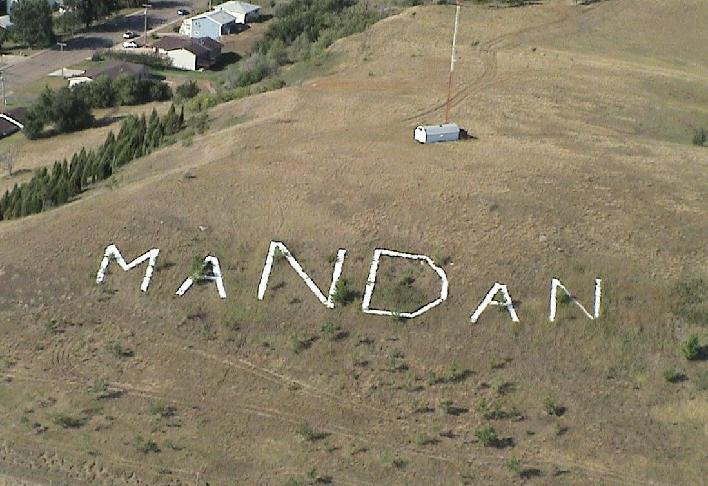
Mandan Hill, or frequently referred to as "Crying Hill", has welcomed visitors and returning residents with its notation for almost 100 years. The landmark is comprised of three separate features; (1) concrete letters denoting the city's name on the northeast face of the hill; (2) the word "Mandan" spelled out in trees on the south face of the hill; and (3) the hill itself, a sacred place culturally important to several Native American tribes.
In the 1920s, small towns across the state and probably across the country adopted the practice of recording its name on a nearby hillside. Similar efforts were undertaken by other North Dakota towns including Bowman, Center, Kathyrn, and New Salem whose signs also remain intact today. In the days before GPS coordinates and radio navigation aids, the forerunner to the ND State Aeronautical Commission encouraged rural areas to denote their community's name on watertowers and hillsides to assist airplane pilots in identifying their location during cross-country flights. Another version of the truth attributes the practice to plain civic pride. The first sign was completed in 1929 by the local Boy Scout troup transporting discarded blocks of pavement they commandeered from the Sixth Avenue NW widening project. Whitewash was provided courtesy of a nearby blacksmith shop. In 1932, Mandan Pioneer newspaper editor Edwin Tostevin suggested for a larger, more substantial version of the sign during a meeting of the Mandan Lions Club. After a two year effort, civic leaders stepped up to formally adopt it as a civic project. Again, the Mandan Boy Scouts lead the effort to complete a 300 foot long by 70-foot-high sign on the south side of Mandan's Crying Hill in June 1934. Area businesses sponsored the forty-seven truckloads of rock which were delivered to the base of the hill. The stones were collected from fields around the city. The Boy Scouts applied more than 12 gallons of white paint to the stones to brighten the letters. Mandan's layout features the two middle characters as upper case letters 85 feet high to represent the state's of North Dakota's official abbreviation. The local Boy and Girl Scouts maintained the sign for 30 years.
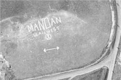
In June 1959, work was again completed on refurbishing and replacing stones and repainting the sign. Railroad ties were added to the display which denoted "Trail West" to promote the new Custer-based drama debuting at Fort Lincoln State Park in July 1959. The project was sponsored by the Mandan Jaycees with member Larry Sullivan serving as project chairman.
In August 1963, eight gallons of paint and 12-hours of effort by the Mandan Jaycees members went into rehabbing the sign. A second line consisting of white painted railroad timbers was added to promote the Custer Drama at Fort Lincoln State Park. In August 1974, 26 members of Mandan's TOPS (i.e., take off pounds sensibly) Club 17 trudged up the bluff (along with a few of their husbands) to replaced missing rocks spelling out both "MaNDan" and "MHS." White paint was provided by the local Chamber of Commerce to help completed the referbishment. With the construction of Interstate 94 on the north side of the hill, the original white-colored sign was transferred from the hill's southern side to the east side in 1987 to be viewed by approaching traffic. Instead of using stones, large concrete rectangles were constructed. This designed was expected to discourage vandals from removing stones and/or destroying the letters. The marker is credited currently as being the largest sign in North Dakota.As part of North Dakota's centennial celebrations, Mandan joined other cities in the state to plant a "Centennial Forest." Trees were planted in 1989 across the original location of the sign, i.e. the southern face of the hill, also spelling out "MANDAN." In September 2024, Doosan Bobcat employees volunteered and cleared the trees and brush around the existing letters.

Originally the plan was to scrape and repaint the concrete panels in Spring 2025. But their current condition demands more of an effort. Three Affiliated Tribes currently owns the property under the letters M, A, N, and D. The City of Mandan own the land under the last two letters: A and N. The City approached the Three Affiliated Tribes to jointly sponsor the project, and they are in general agreement with the need to update the lettering.
A group of residents and city staff and leaders to develop a specific plan for the project. The Four Directions group at Mandan High School suggested "Honoring the past. Healing the future." as the theme for the project. A landscape architect was engaged. The preferred concept alternative involves 20-feet high and 130 feet wide and includes LED lighting to illuminate the sign. The estimated cost is $1.2 million. City leaders are now soliciting private funds to sponsor the project.
Crying HillThe first European explorers, sons of the famous French explorer Pierre Verendrye, were reportedly greeted in 1738 by Mandan indian chief Good Fur Blanket just below the south side of the hill. However the greater significance stems from its importance to multiple Native American Indian tribes. The Mandan, Hidatsa, Lakota, Sioux, and Arikara tribes all attribute sacred events and rituals of taking place there.
As the highest place in the area, Crying Hill was frequently sought out as a place for prayer and solace; possibly asking for a healthy baby by pregnant women; or a attempting a “vision quest” seeking guidance from a departed loved-one. The area was also used by Native Americans from the region to mourn their dead.Whether its importance is of cultural significance, or evokes fond childhood memories sledding down its slippery snowing slopes, the place is a true historic landmark.
Copy-edited article
Mandan Hill, frequently called Crying Hill, has welcomed visitors and returning residents with its lettering for nearly a century. The landmark comprises three separate features: concrete letters spelling the city's name on the hill's northeastern face; the word "Mandan" spelled in trees on its southern face; and the hill itself, a sacred place of cultural importance to several Native nations.
The Mandan sign
During the 1920s, small towns across North Dakota and elsewhere placed their names on nearby hillsides. Signs remain at Bowman, Center, Kathryn, and New Salem. Before GPS and radio-navigation aids, the predecessor of the North Dakota Aeronautics Commission encouraged rural communities to mark their names on water towers and hillsides to help pilots identify their location during cross-country flights. Another explanation attributes the practice simply to civic pride.
The first Mandan sign was completed in 1929 by local Boy Scouts, who carried discarded paving blocks from the Sixth Avenue NW widening project to the hill. A nearby blacksmith shop provided whitewash. In 1932, Mandan Pioneer editor Edwin Tostevin proposed a larger, more substantial sign during a Mandan Lions Club meeting. After two years, civic leaders formally adopted the work as a community project.
The Mandan Boy Scouts led construction of a sign 300 feet long and 70 feet high on the southern face of Crying Hill in June 1934. Area businesses sponsored 47 truckloads of rocks collected from fields around the city. The Scouts used more than 12 gallons of white paint on the letters. The two middle characters—an uppercase N and D—were 85 feet high and represented North Dakota's official abbreviation. Local Boy and Girl Scouts maintained the sign for 30 years.
The sign was refurbished in June 1959. Missing stones were replaced, the letters were repainted, and railroad ties spelling "Trail West" were added to promote the new Custer drama opening at Fort Lincoln State Park that July. The Mandan Jaycees sponsored the work, with member Larry Sullivan serving as project chairman.
In August 1963, Mandan Jaycees spent 12 hours and eight gallons of paint rehabilitating the sign. A second line of white-painted railroad timbers promoted the Custer Drama at Fort Lincoln State Park. In August 1974, 26 members of Mandan's TOPS Club 17, accompanied by several husbands, replaced missing rocks in both "MaNDan" and "MHS." The Chamber of Commerce provided white paint.
Construction of Interstate 94 north of the hill prompted the sign's relocation from the southern face to the eastern face in 1987, where it could be seen by approaching traffic. Large concrete panels replaced the loose stones to discourage vandalism. The marker has been described as North Dakota's largest sign.
As part of North Dakota's centennial celebration, Mandan planted a "Centennial Forest" in 1989 across the sign's original location on the southern face, with the trees also spelling "MANDAN." In September 2024, Doosan Bobcat employees cleared trees and brush around the concrete letters.
A plan to scrape and repaint the concrete panels in spring 2025 grew into a more extensive proposal because of their condition. The Three Affiliated Tribes owns the land beneath the letters M, A, N, and D, while the City of Mandan owns the land beneath the final A and N. The city approached the Tribes about jointly sponsoring the project, and both agreed that the lettering needed attention.
Residents, city staff, and community leaders developed a plan around the theme "Honoring the past. Healing the future," suggested by the Four Directions group at Mandan High School. The preferred concept measured 20 feet high and 130 feet wide and included LED illumination. Its estimated cost was $1.2 million, to be raised through private sponsorships.
Crying Hill
The sons of French explorer Pierre Gaultier de Varennes, sieur de La Vérendrye, were reportedly greeted in 1738 by Mandan chief Good Fur Blanket near the southern side of the hill. The hill's greater significance, however, comes from its importance to several Native nations. Mandan, Hidatsa, Lakota, Sioux, and Arikara traditions associate the place with sacred events and ceremonies.
As the highest point in the area, Crying Hill was sought as a place for prayer and solace. Pregnant women may have gone there to pray for healthy babies, while others undertook vision quests or sought guidance from departed loved ones. Native people of the region also used the area to mourn their dead.
Whether valued for its cultural significance or remembered as a childhood sledding hill, the place remains a historic Mandan landmark.